
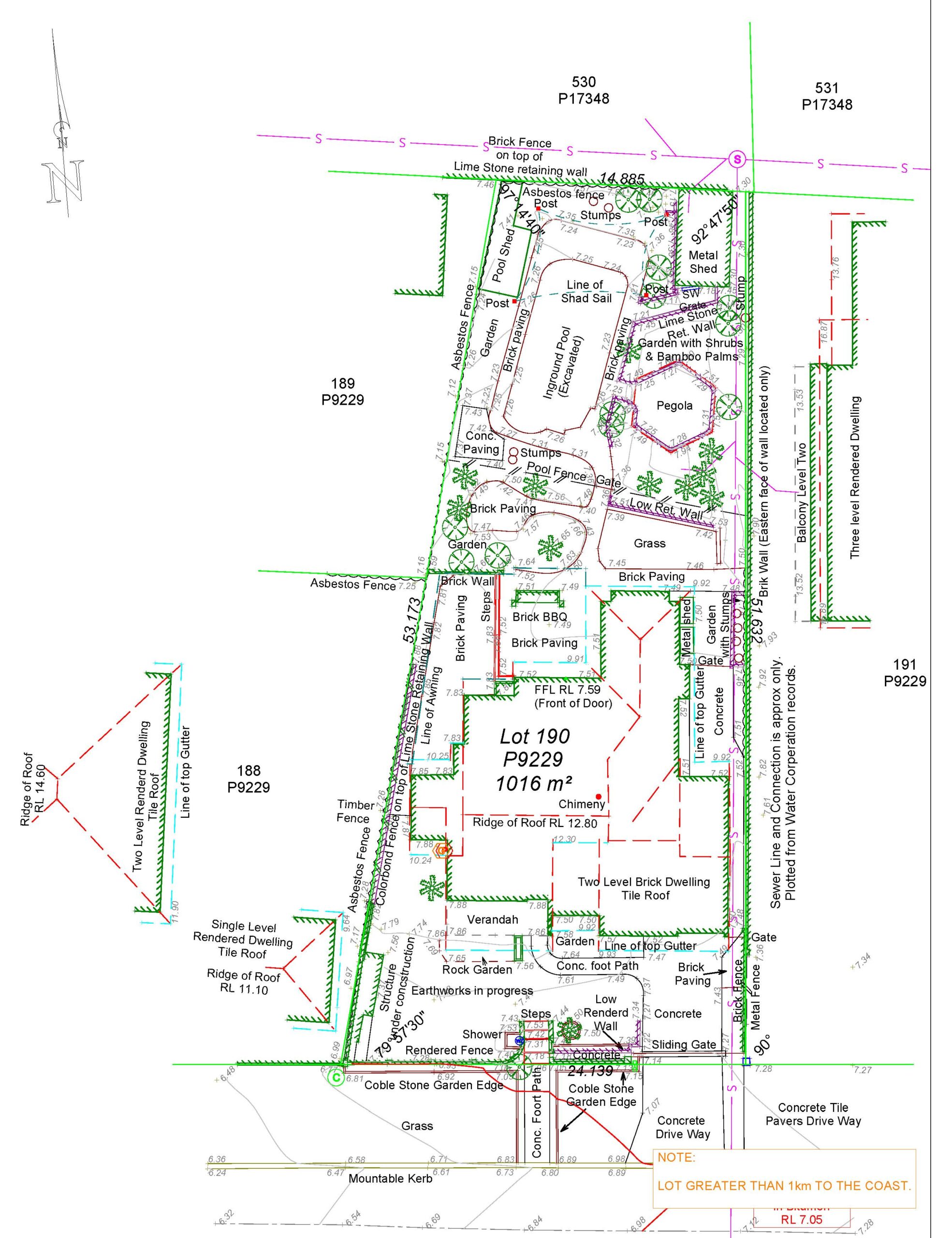
Land assessment and beyond, feature and contour surveys offer indispensable insights into terrain characteristics. They provide critical data for homeowners, investors, and professionals, unveiling essential details like natural features, elevation changes, and property boundaries. With their precision and accuracy, these surveys optimize landscaping, drainage solutions, and development projects, ensuring maximum value and stability. Their applications extend across various sectors, from environmental conservation to urban planning, emphasising sustainability and responsible land management practices.
Why Feature and Contour Surveys Matter

These detailed analyses act like a roadmap, revealing a property’s hidden potential. Homeowners can leverage this information to optimise their land for landscaping, drainage solutions, or even future additions. For investors, the survey becomes a key to unlocking development opportunities. By understanding the property’s slopes, contours, and potential hazards, informed decisions can be made that maximise value, ensure stability, and ultimately bring peace of mind. As it captures:
Natural features: This includes information on topography, vegetation, and existing structures.
Property boundaries: Accurate property lines are essential for legal purposes and development plans.
Powering Efficiency: Benefits for Land Development Projects

Land development gets a shot at efficiency with feature and contour surveys. These surveys reveal the land’s secrets, like slope and elevations, allowing for smarter site planning and building placement. They also sniff out potential problems early on, preventing construction delays. By streamlining the process, these surveys become an investment that pays off for successful land development projects. Here’s how:
Minimised Construction Delays:
Reduced Construction Costs:
Precise knowledge of the land’s features guides optimal land use decisions, ensuring compatibility with the project’s purpose and maximising its potential.
Sustainable Development Practices:
Beyond Development: Applications in Diverse Fields

These surveys hold value in surprising fields. Imagine environmentalists using them to design erosion control or archaeologists uncovering hidden sites. Farmers can leverage them to optimise crop yields, while landscape architects plan stunning outdoor spaces. Even disaster management teams rely on these surveys for post-catastrophe reconstruction. The diverse applications for continue to grow, proving their usefulness extends far beyond the realm of land development. Beyond land development, feature and contour surveys have applications in several other sectors:
Property Value Assessment: Accurate land measurements and knowledge of existing features are crucial for determining a property’s fair market value.
Infrastructure Development: Precise information on feature and contour surveys is essential for planning roads, bridges, and other infrastructure projects.
Urban Planning: Aid in creating efficient and sustainable urban environments by informing infrastructure development, drainage plans, and land use optimization.
Environmental Management: Understanding the land’s natural features and drainage patterns is crucial for effective environmental protection and management strategies.
Archaeological Investigations: Can be used to identify potential archaeological sites based on subtle changes in topography.
How Feature and contour surveys used for sustainable Development practices?

Sustainable development is a pressing concern in today’s world, and feature and contour surveys can play a vital role in promoting environmentally friendly practices. By providing detailed information about the land’s topography, drainage patterns, and ecological features, these surveys enable developers to design projects that minimise environmental impact and maximise resource efficiency. From green spaces to renewable energy installations, feature and contour surveys pave the way for a more sustainable future.
Smart Drainage: They reveal natural drainage patterns, enabling efficient systems that minimise erosion and flooding, key principles of sustainable water management.
Sustainable Feature Integration: Knowing land characteristics helps integrate features like rainwater harvesting or strategically placed solar panels, lowering the project’s environmental footprint.
Long-Term Sustainability: Baseline data from the surveys helps with long-term planning and monitoring the project’s environmental impact.
For a more detailed discussion on feature and contour surveys and how that is beneficial, visit our online website, PSS GROUP. We can provide expert advice and ensure you receive a survey tailored to your needs.Head over to our PSS Group for more detailed discussions on feature and contour surveys. Get expert advice to ensure you get a survey perfectly tailored to your specific needs today.


")