fbpx //Tracker

Save Time and Money: Plan Ahead with Feature and Contour Surveys

Stay on Budget and Eliminate Unexpected Expenses with Our Surveys

Are you considering making improvements or modifications to your existing house? Don’t let unexpected expenses and delays ruin your plans. Our feature and contour surveys offer the perfect solution to help you plan ahead, save time, and stay on budget

Homeowners often face costly surprises and unexpected expenses during construction or home improvement projects.

These surprises can lead to budget overruns, delays, and frustration, causing stress and inconvenience. Our feature and contour surveys enable effective planning, providing you with detailed information about your property, such as elevation changes, existing structures, and potential obstacles. By utilizing our surveys, you can avoid costly modifications during construction, save time, and ensure your project stays on budget.

Stay on budget and save time

We understand the importance of cost savings in today’s competitive landscape. Our pricing structure is designed to be highly competitive, ensuring that you receive exceptional value for your investment.

Peace of mind with accurate, detailed surveys

Accuracy is the cornerstone of our surveying services. We utilize state-of-the-art technology, including advanced GPS systems and 3D laser scanning, to ensure precise measurements and detailed mapping

Free consultation

We provide free consultations to our clients to ensure they gain a comprehensive understanding of the land surveying process to make informed decisions, save costs, Clarify expectations taylor solutions and give our clients an educational experience. 

Avoid costly mistakes

While there is a cost associated with feature and contour surveys, they are a valuable investment. They provide crucial information about your property’s characteristics, helping you avoid costly surprises, design improvements efficiently, and make informed decisions about renovations, landscaping, or future developments.

Quality Land Development

 To make informed decisions and avoid surprises, professional surveys are essential for an in-depth understanding of your property

Maximizing the value of the property

A professional survey conducted by qualified surveyors offers an unbiased and accurate assessment, ensuring that you have complete information about your property’s characteristics and potential challenges to maximise your investment

Completed Feature Surveys

Completed Projects

Renovation

Here Is What Our Customers Have to Say

Great Service!

Service and works supplied from PSS has been great, from the office to our surveyor on site no issues at all, would definitely recommend.

-Trevor Seeley

Amazing to Work With!

PSS Group were amazing to work with. They delivered great projects in record time. I would be using them again. Thanks Chris and team!

-Vanesa Gonzalez

A Pleasure!

The PSS team are a pleasure to work with. They are easy to deal with and provide a great service.


-Brayden Murphy

Ready to receive a FREE personalized quote for our exceptional surveying services?

Fill out our hassle-free and quick free quote form today. Just provide us with some basic details about your project and specific surveying requirements, and our dedicated team will swiftly assess your needs and provide you with a competitive and comprehensive quote. Don’t miss out on this opportunity to unlock the insights and benefits that professional surveying can bring to your project. Take the first step towards accuracy and efficiency by completing our free quote form now or call us at +61 8 9303 2407 so we can start your survey.

Let’s Build Something Together

We understand the complexities and challenges involved in land development.

We’re here to eliminate uncertainty and provide clarity for your project.

With 30 years of industry experience and a portfolio of successful projects, we have proven expertise

What is a feature survey and why is it important?

A feature survey, also known as a topographic survey, is a survey conducted to map and document the physical features and characteristics of a property or land parcel. It involves capturing data on elevations, contours, existing structures, vegetation, water bodies, and other natural or man-made features. A feature survey is essential as it provides valuable information for various purposes such as land development, engineering design, construction planning, and environmental assessments. It helps understand the existing conditions of the land, identify potential constraints or opportunities, and aids in making informed decisions about land use and development. A feature survey provides accurate and detailed information about the site, enabling architects, engineers, and planners to design and implement projects effectively while considering the existing landscape and features. Whether you’re a homeowner, property developer, or investor, a feature survey is a valuable tool that helps you understand and utilize the full potential of the land.

What does a feature survey typically include?

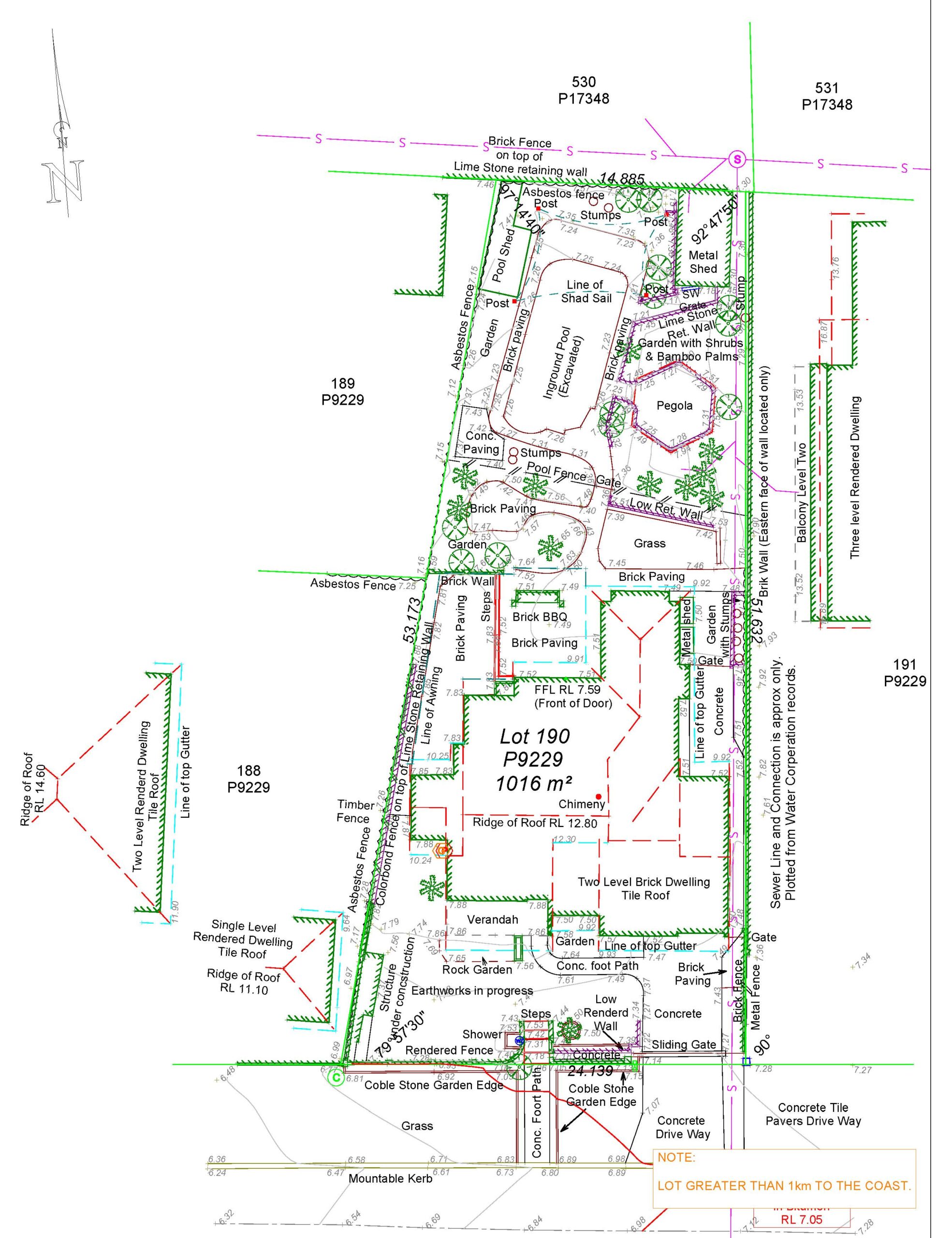
A feature survey typically includes a comprehensive mapping of the physical features of a property or land parcel. It involves capturing data on the existing terrain, including contours, spot elevations, and slopes. The survey also identifies and maps existing structures, such as buildings, driveways, and fences, along with their dimensions and heights. Vegetation, including trees and shrubs, is documented, and any significant landscape features, such as water bodies, slopes, or natural formations, are included in the survey. Additionally, utility infrastructure, such as power lines, stormwater drains, or sewer lines, may be captured if they are visible or have an impact on the site. The extent of the feature survey depends on the specific requirements of the project or purpose for which it is being conducted. A professional land surveyor experienced in feature surveys can tailor the survey scope to capture the necessary information for your particular needs.


How long does it take to conduct a feature survey?

The duration of a feature survey depends on various factors, including the size and complexity of the site, the desired level of detail, and the surveyor’s workload. Generally, a standard residential feature survey can be completed within a few days to a couple of weeks. However, larger or more intricate sites, such as commercial or industrial properties, may require more time for data collection and processing. It’s important to consult with a professional land surveyor who can assess the specific requirements of your project and provide an estimate of the survey duration. Keep in mind that it’s crucial to prioritize accuracy and quality in a feature survey, as the data collected will serve as a foundation for future planning and design decisions.


Can a feature survey be used for construction or development purposes?

Yes, a feature survey is commonly used for construction or development purposes. The detailed information and mapping provided by a feature survey are essential for architects, engineers, and planners during the design and planning stages of a project. It allows them to understand the existing site conditions, including slopes, contours, and existing structures, and enables them to incorporate these factors into their design and engineering plans. A feature survey assists in proper site grading, designing drainage systems, identifying potential challenges or constraints, and optimizing the design for the specific site conditions. It also helps in complying with local regulations and environmental considerations. Whether it’s a residential construction project, commercial development, or infrastructure planning, a feature survey provides the necessary data and insights to make informed decisions and ensure successful project outcomes.


Can a feature survey help identify potential hazards or environmental considerations on a property?

Yes, a feature survey can help identify potential hazards or environmental considerations on a property. By capturing detailed information about the existing terrain, vegetation, and water bodies, a feature survey allows for the identification of potential environmental risks or constraints. It can help identify areas prone to flooding, slopes that may require stabilization, or areas with protected vegetation or wildlife habitats. This information is valuable for developers, homeowners, and project planners to understand and mitigate potential risks and ensure environmentally responsible development. Additionally, a feature survey can assist in compliance with environmental regulations and provide the necessary information for conducting environmental impact assessments or developing sustainable land management plans. A professional land surveyor with expertise in feature surveys can assess the specific environmental considerations of a property and provide valuable insights for sustainable and responsible development practices.


Can a feature survey help with landscape design or outdoor improvements?

Yes, a feature survey can be highly beneficial for landscape design or outdoor improvements. By providing accurate information about the existing terrain, slopes, and vegetation, a feature survey assists in designing outdoor spaces that are harmonious with the natural surroundings. It helps landscape architects and designers understand the site’s topography and existing features, allowing them to create designs that work in harmony with the land. A feature survey enables the precise positioning of elements such as pathways, gardens, water features, and outdoor structures, ensuring they are integrated seamlessly into the existing landscape. It also assists in planning proper drainage systems, identifying areas suitable for specific plants or vegetation, and optimizing the design for the site’s unique characteristics. Whether you’re planning a backyard transformation or a larger-scale landscape project, a feature survey provides the essential information to create functional, aesthetically pleasing, and sustainable outdoor spaces.


Is a feature survey necessary for residential property owners?

While a feature survey is not always a legal requirement for residential property owners, it can be highly beneficial. A feature survey provides homeowners with accurate information about their property’s characteristics, allowing them to make informed decisions about landscaping, outdoor improvements, or potential additions to their homes. It helps homeowners understand the existing terrain, drainage patterns, and vegetation, which can be valuable when planning outdoor projects or renovations. Additionally, a feature survey can help homeowners assess potential hazards or environmental considerations on their property and take necessary precautions. While it may require an investment, obtaining a feature survey can provide long-term benefits and save homeowners from costly mistakes or surprises related to their property’s characteristics. Consulting with a professional land surveyor experienced in feature surveys can help homeowners understand the value and relevance of a feature survey for their specific property.


Can a feature survey be used for property boundary identification?

Yes, a feature survey can assist in property boundary identification to some extent. While a feature survey primarily focuses on mapping the physical features and characteristics of a property, it may include boundary markers or indicators as part of the survey. These indicators can help property owners gain a general understanding of their property’s boundaries but should not be considered legally definitive. For precise boundary identification, a separate boundary survey may be necessary, which specifically focuses on determining and documenting the exact property boundaries. If you require precise boundary identification, it is recommended to consult with a professional land surveyor experienced in boundary surveys, as they possess the expertise and knowledge to accurately establish property boundaries in accordance with legal records and documentation.


Can a feature survey be conducted on any type of property, including undeveloped or natural areas?

Yes, a feature survey can be conducted on any type of property, including undeveloped or natural areas. Whether it’s a residential lot, commercial site, or a vast expanse of natural land, a feature survey provides valuable information about the property’s characteristics and topography. In undeveloped or natural areas, a feature survey assists in understanding the existing terrain, water features, and vegetation, which is particularly important for environmental assessments, conservation planning, or sustainable land management. It helps identify potential environmental considerations, areas of ecological significance, or sensitive habitats. By conducting a feature survey on undeveloped or natural areas, landowners, environmental agencies, and conservationists can make informed decisions about land use, conservation strategies, or development plans while considering the existing landscape and ecological factors. Consulting with a professional land surveyor experienced in feature surveys can help tailor the survey approach to the specific requirements of undeveloped or natural properties.


Can I perform a feature survey myself using consumer-grade GPS or mapping tools?

While consumer-grade GPS devices and mapping tools have become more accessible, conducting a reliable and accurate feature survey requires professional expertise and specialized equipment. Consumer-grade GPS devices typically have lower accuracy levels compared to survey-grade GPS equipment used by professional surveyors. Feature surveys involve precise measurements, elevation data, and detailed mapping, which require specialized surveying instruments and software. Professional land surveyors have the knowledge and experience to collect accurate data, process it appropriately, and produce reliable survey reports. They are also familiar with local regulations, coordinate systems, and mapping standards, ensuring that the survey results are compatible with other professional datasets. To ensure the quality and accuracy of a feature survey, it is recommended to engage a licensed and experienced land surveyor who can provide reliable surveying services tailored to your specific needs.


Expert Insight, Better Decisions: Harness the Power of Feature and Contour Surveys

Stress-Free Build? Get a Feature and Contour Survey Now!

Stress-Free Build? Get a Feature and Contour Survey Now!

Feature & Contour Surveys Your Key to a Stress-Free Project Surveying is more than just measuring land; it's about building confidence in your project. Accurate, detailed feature and contour surveys are the foundation for informed decision-making, helping you...

Beyond Surface: Power of Feature & Contour Surveys

Beyond Surface: Power of Feature & Contour Surveys

Land assessment and beyond, feature and contour surveys offer indispensable insights into terrain characteristics. They provide critical data for homeowners, investors, and professionals, unveiling essential details like natural features, elevation changes, and...

Potential Property Safety and Security

Potential Property Safety and Security

As a homeowner, you want to make the most of your property. Whether you’re considering renovations, landscaping changes, or future developments, having a clear understanding of your property’s features and contours is crucial

Design with Confidence:

Design with Confidence:

As a homeowner, you understand the importance of making informed decisions when it comes to upgrading your property